Materials Mechanics
Monocular 3D Video Extensometer



Monocular 2D Optical Strain Measurement System
Monocular 3D Optical Strain Measurement System
High-Speed Monocular 3D Optical Strain Measurement System
Stereo 3D Optical Strain Measurement System
Optical Strain Measurement System – Educational Edition
2D Optical Microscopic Strain Measurement System


Strain Measurement of Parallel Lap Welds
Residual Deformation Measurement of Drilled Welded Plates
Full-Field Strain Measurement of Weldments in Compression
Tensile Deformation Measurement of 0.3mm Fiber Filament
Unmarked Compression Deformation Measurement of Composite Materials

Deformation Measurement of Artificial Cardiac Patch
Keycap Vibration Measurement: Quantifying Press and Rebound Dynamics
Headband Deformation Measurement: Analyzing Bending Position and Unloading Recovery
High-Temperature DIC Measurement of Wafer Thermal Warpage: Quantifying Warpage vs. Temperature
UAV Dynamic Tracking Measurement: Capturing Flight Trajectory and Attitude Changes

 0755-86347753

Published: 2026-07-28
The difficulty of highway slope displacement monitoring is not only whether displacement can be measured, but also whether equipment can run long-term in remote environments, how on-site power and communication problems are solved, how large-span slopes can be flexibly arranged, and whether timely warning is possible after monitoring anomalies occur.
For slope monitoring scenarios such as mountain highways, expressways and county/township roads, the online visual tracker uses non-contact image measurement to continuously acquire displacement data at key slope positions and uploads the results to a remote management platform, providing a data basis for slope risk assessment, on-site review and safety response.
Highway slopes are usually widely distributed and significantly affected by geological conditions, rainfall, construction disturbance and road operation environments.
Continuous rainfall may increase the water content of rock and soil, and construction excavation and vehicle vibration may also aggravate local loosening. Before obvious sliding occurs, some slopes usually go through a process of slow deformation and gradual displacement accumulation.
Therefore, slope monitoring cannot rely only on single measurements or periodic manual inspection; the following information must be continuously mastered:
▪ Whether the slope has displaced;
▪ How large the displacement is;
▪ Whether displacement keeps developing;
▪ Whether changes at different monitoring points are synchronized;
▪ Whether displacement reaches the preset warning threshold.
Long-term, continuous displacement data helps managers identify slope change trends, judge whether anomalies are short-term fluctuations or continuous development, and provide a reference for subsequent response.
Many highway slopes are far from urban areas, lacking stable power and wired networks on site. Relying entirely on mains power and fixed communication lines may bring long construction periods, high wiring costs and inconvenient later maintenance.
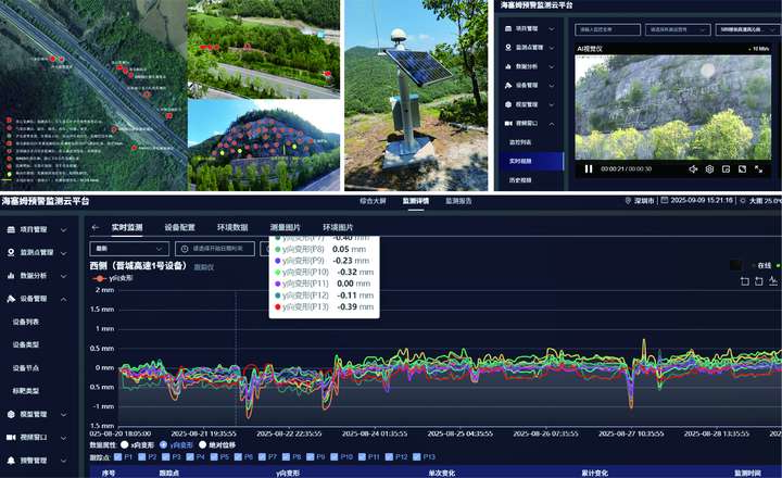
In the Jincheng expressway slope displacement automated monitoring project, Haytham Technology adopted a battery and solar power scheme according to site power conditions, achieving 1Hz displacement data acquisition.
With this deployment, monitoring equipment can run continuously with less on-site wiring and infrastructure dependence. Managers can remotely learn the displacement changes of key slope areas without frequently traveling to the site.
Solar and battery power solutions suit the following scenarios better:
▪ Mountain highway slopes;
▪ Slopes along expressways;
▪ Remote county and township roads;
▪ Temporary construction slopes;
▪ Monitoring areas without stable mains power.
For remote slopes, the monitoring system must not only be able to measure; practical issues such as power consumption, power supply mode, data upload and equipment maintenance must also be considered.
Slope surfaces are usually irregular; different monitoring areas may have elevation differences, occlusion and sight restrictions.For long-distance, large-span slopes, a single fixed viewpoint often cannot cover all key positions.
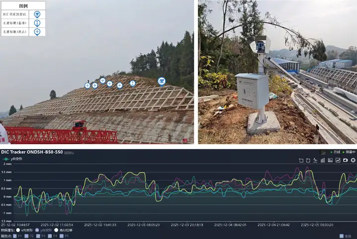
In the Pingyi Expressway slope monitoring project,The project adopts a flexible monitoring arrangement with front and rear cameras, adjusting device placement according to the spatial structure of the slope and on-site sight conditions, so that multiple monitoring areas form a continuous data link.
flexible vision monitoringis not simply adding equipment numbers, but designing the linkage between different devices and monitoring points according to site conditions, therebyAdaptation:
▪ Long-distance slope monitoring;
▪ Large-span slope monitoring;
▪ Irregular slope surface monitoring;
▪ Complex scenes with occlusion;
▪ Continuous displacement monitoring of multiple areas.
When a single monitoring viewpoint cannot cover all measuring points, front-rear measuring devices or multi-device collaborative arrangement can expand the monitoring range while maintaining data continuity between different areas.
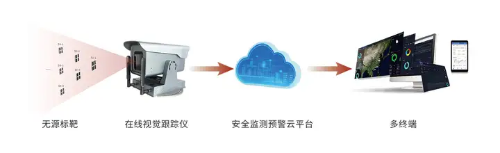
The online visual tracker identifies targets placed at key slope positions, continuously captures their position changes in images, and calculates slope displacement using system calibration parameters.
Compared with manual periodic measurement, vision monitoring enables automatic acquisition, remote transmission and continuous recording. Managers can view displacement data and change trends of different periods through the monitoring platform.
Its basic workflow includes:
▪ Set monitoring targets according to slope structure and risk positions;
▪ Install vision monitoring equipment in stable areas;
▪ The system continuously recognizes and tracks target positions;
▪ Compute the displacement changes of each monitoring point;
▪ Upload monitoring data to the remote platform;
▪ Alarm triggered when displacement reaches the preset threshold.
Because of the non-contact measurement approach, monitoring equipment does not need to be installed directly on the slope deformation area, reducing the impact of complex slope environments on sensor installation and maintenance.
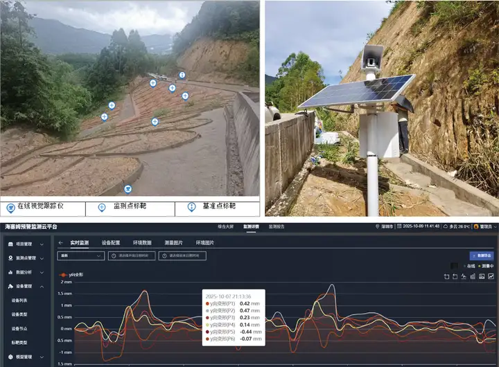
In the Zhangzhou slope displacement monitoring project, the online visual tracker continuously identifies targets at key slope positions, acquires displacement data and uploads it to the remote platform.
Managers can view slope displacement, change times and development trends on the platform.When monitoring data reaches the preset threshold, the system issues alarm information in time, buying time for on-site review, risk assessment and response decisions.
Slope monitoring warning cannot focus only on the value at one time point; it also needs comprehensive judgment combining displacement rate, duration and historical trends。
For example, short-term fluctuation at one monitoring point may relate to weather, lighting or construction disturbance; if displacement keeps increasing, or multiple monitoring points show trend changes simultaneously, the attention level should be raised and on-site inspection arranged.
Therefore, the value of an automated monitoring system is not only recording data, but forming a continuous time series that allows managers to judge whether slope changes are persistent and developing.
online visual tracker can be applied to slope displacement monitoring of expressways, ordinary highways, county and township roads and construction areas, especially suitable for projects with scattered monitoring points, complex site environments or long-term remote monitoring needs.
In slope monitoring projects, common application scenarios include:
▪ Displacement monitoring of high expressway slopes;
▪ Slope stability monitoring of mountain roads;
▪ Geological disaster monitoring of county and township highways;
▪ Deformation monitoring of cutting slopes;
▪ Slope monitoring for construction excavation;
▪ Densified monitoring of key slopes during rainfall;
▪ Continuous monitoring of long-distance, large-span slopes.
In actual projects, the number of devices, installation positions and data acquisition frequency should be determined according to slope length, gradient, monitoring distance, sight conditions, power supply mode and communication environment.
For the characteristics of highway slopes — wide distribution, complex environments and difficult management,online visual tracker can provide the following monitoring capabilities:
1. Non-contact displacement measurement
By recognizing and tracking monitoring targets with cameras, there is no need to deploy large numbers of wired sensors in deformation areas, adapting to complex slopes and hard-to-access monitoring positions.
2. Automated continuous acquisition
The system can automatically acquire displacement data at set frequencies, reducing the time gaps caused by relying entirely on manual inspection and manual recording.
3. View monitoring data remotely
Monitoring results can be uploaded to the platform, allowing managers to remotely view the displacement and change trends at different slope positions.
4. Solar and battery power support
For mountains and highway sections lacking mains power, solar and battery power can be configured according to site conditions, reducing dependence on fixed wiring.
5. Flexible expansion deployment support
For large-scale, long-distance or occluded slopes, the monitoring range can be expanded through front-rear cameras and multi-device collaboration.
6. Threshold alarm support
When displacement reaches the preset threshold, the system can issue alarm information, providing timely data prompts for on-site review and risk response.
Slope risks usually do not form suddenly; they gradually accumulate under long-term rainfall, rock-soil loosening, construction disturbance, environmental changes and other factors.
The Haytham online visual tracker incorporates slopes scattered across mountainous areas, along highways and in construction zones into a continuous monitoring system through non-contact, automated and remote monitoring.
Managers can learn not only whether the slope has changed, but also how much the displacement changed, whether it keeps developing, and whether it has reached a level requiring attention.
From expressways to county and township roads, from solar-powered remote sites to flexible deployment on large-span slopes, Haytham Technology can design vision-based displacement monitoring solutions for different site conditions, providing continuous data for slope safety management, risk assessment and on-site response.


 Downloads